Moldova – Indicators
Gheorghe is a 65 years old man who lives in a remote area of the village C. He is already retired, but still works part time in a city nearby. He considers himself to be relatively healthy and is in no need of fast and easy access to a health institution. Still, he has several chronic conditions that need periodic check from a family doctor’s office which is about 3 km distance from his home. Although he needs to face long waiting lists and to spend time when visiting his family doctor, Gheorghe accepts that this is the “price for living away from a big city”.
A couple of years ago he benefited by a state program “Un doctor pentru tine” which granted access to health check up and screening check-ups in remote rural areas for the population that cannot travel to bigger cities. He regrets that this program is not in place anymore, but acknowledges the limited resources that the state has and tries to keep a good relation with the family doctor from his village.
A couple of years ago Gheorghe was happy that a young professional family doctor arrived to work in his village and all the small health emergencies that he and his neighbours have will be solved. Unfortunately, after 3 mandatory years that the young professional has worked in this rural area, the family doctor left for the capital city. Gheorghe understands that the opportunities for professional development are limited in his city and has no hard feelings on the young family doctor that left.
Last year a new young professional came to work in the family doctor’s office in his village and Gheorghe and his neighbours are happy again. Although, the young doctor has a good relationship with the population within the village C, there are rumours that he is already looking for some opportunities to go work abroad the country.
Besides the risk of having no family doctor in his village, Gheorghe is having also difficulties in accessing the laboratory diagnostic procedures, since the closest laboratory is within the district hospital which is more than 50 km away and with the prospect of having no family doctor to grant these procedures he eventually will require, only hope remains in his mind.
When it comes to drugs and dental care, Gheorghe relies only on himself: when he is on duty at work in the city, he goes to the closest drug store and gets the needed drugs, with no possibility to access a drug store in his village in other days. If Gheorghe needs some dental care or regular check up, he goes to the capital city to a private clinic, since there is almost no chance for him to get an appointment to a state clinic. In order to afford his drugs and dental care, Gheorghe sets aside some money on a regular basis and relies on his daughters who live in other country for financial support if he would encounter some serious medical condition in the future.
Gheorghe thinks that his situation is not the worst, but still hope for better health access to the health system in the nearest future for him and his neighbours from the village C. He is thankful for not having some other severe health conditions that would require permanent check-ups and fast and easy access to the health system.
On this page, you can the following information about medical desertification in Moldova:
1) An illustrative story about an individual affected by medical desertification in Moldova
2) Our country report on medical deserts in Moldova
3) A selection of indicators for background information about Moldova
4) Our Medical Deserts Diagnostic Tool: maps based on the contextualised set of indicators
This is a map of the Republic of Moldova showing the total population, per municipality, as a possible indicator of healthcare access, color-coded from light green (the lowest number) to dark blue (highest number).
For more information click on the MAP!
This is a map of the Republic of Moldova showing the total number of primary health care public institutions, per municipality, as a possible indicator of healthcare access, color-coded from light green (the lowest number) to dark blue (highest number).
For more information click on the MAP!
This is a map of the Republic of Moldova showing the total number of family doctors, per municipality, as a possible indicator of healthcare access, color-coded from light blue (the lowest number) to dark blue (highest number).
For more information click on the MAP!
This is a map of the Republic of Moldova showing the total number of family doctors’ nurses, per municipality, as a possible indicator of healthcare access, color-coded from light blue (the lowest number) to dark blue (highest number).
For more information click on the MAP!

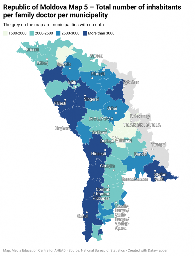
This is a map of the Republic of Moldova showing the number of inhabitants per family doctor, in each municipality, as a possible indicator of healthcare access, color-coded from light blue (the lowest number) to dark blue (highest number).
For more information click on the MAP!
This is a map of the Republic of Moldova showing the total number of inhabitants per family doctor’s nurse, per municipality, as a possible indicator of healthcare access, color-coded from light blue (the lowest number) to dark blue (highest number).
For more information click on the MAP!
This is a map of the Republic of Moldova showing the total number of prehospital EMS (emergency medical services) centers, per municipality, as a possible indicator of healthcare access, color-coded from light blue (the lowest number) to dark blue (highest number).
For more information click on the MAP!
On this page, you can the following information about medical desertification in Romania:
1) An illustrative story about an individual affected by medical desertification in Romania
2) Our country report on medical deserts in Romania
3) A selection of indicators for background information about Romania
4) Our Medical Deserts Diagnostic Tool: maps based on the contextualised set of indicators
This is a map of Romania showing the number of general practitioners (GP) per municipality, and per 10.000 inhabitants as a possible indicator of healthcare access.
For more information click on the MAP

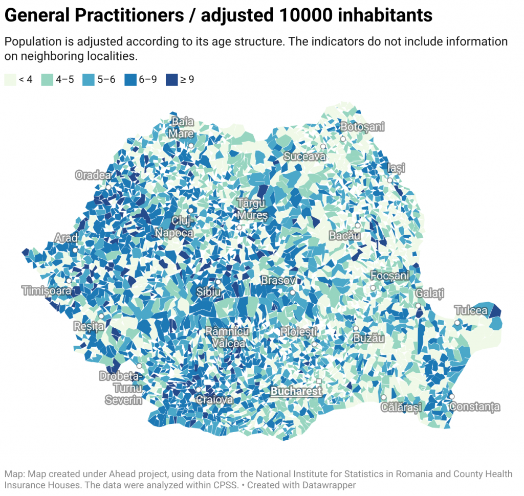
This is a map of Romania showing the number of general practitioners (GP) per municipality, and per 10.000 adjusted inhabitants.
For more information click on the MAP!

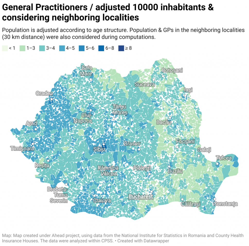
This is a map of Romania showing the number of general practitioners (GP) per municipality, and per 10.000 adjusted inhabitants and considering also the supply and demand in neighboring localities.
For more information click on the MAP!
Simple counts are used for number of pharmacies, respectively population size.
This is a map of Romania showing the number of pharmacies per municipality, and per 10.000 inhabitants.
For more information click on the MAP
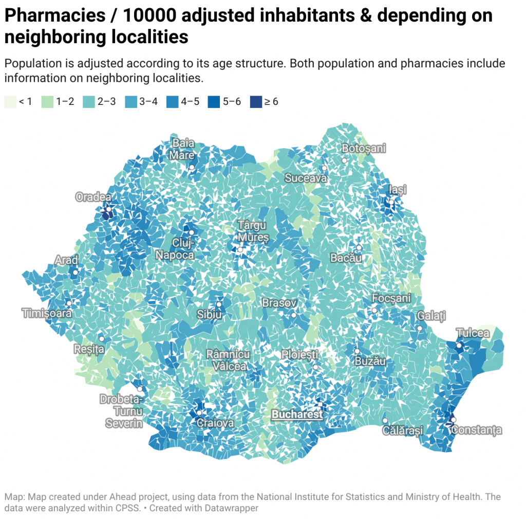
Simple counts are used for number of pharmacies. Population is adjusted according to its age structure.
This is a map of Romania showing the number of pharmacies per municipality, and per 10.000 adjusted inhabitants.
For more information click on the MAP
 Map 6: Pharmacies / 10000 adjusted inhabitants & depending on neighboring localities
The index is taking into consideration only the unadjusted population of the locality and the number of pharmacies from that locality.
Localities are colour-coded from light blue (lowest numbers) to dark blue (highest numbers).
For more information click on the MAP
Population is adjusted according to its age structure. Both population and hospitals include information on neighboring localities.
This is a map of Romania showing the number of level 1-3 hospitals per municipality, and per 1 million adjusted inhabitants, and also considering the supply and demand within 30 km catchment area
For more information click on the MAP
Population is adjusted according to its age structure. Both population and hospitals include information on neighboring localities.
This is a map of Romania showing the number of level 1-5 hospitals per municipality, and per 1 million adjusted inhabitants, and also considering the supply and demand within 30 km catchment area
For more information click on the MAP